The Caspian's Dual Identity: Geological Legacy and the Etymology of 'Lihai'
Hydrologically, the Caspian Sea is the world's largest inland saline lake. Geologically, however, it retains the oceanic crust of the ancient Paratethys Sea. This essay dissects the 'sea versus lake' debate, the geopolitical maneuvering behind the 2018 Caspian Sea Convention, and traces the academic evolution of the Chinese name 'Lihai' from Qing Dynasty texts.

Executive Summary: Straddling the Eurasian landmass, the Caspian Sea, with its surface area consistently between 370,000 and 390,000 square kilometers, is the planet’s largest inland body of water. Modern hydrology unequivocally classifies it as a closed, endorheic saline lake. Yet, geologically, it preserves the deep-sea basaltic oceanic crust and marine ecological remnants of the ancient Paratethys Sea. Following the Cold War, the five littoral states engaged in a nearly three-decade-long geopolitical struggle over multi-billion dollar oil and gas pipelines and territorial sovereignty. This culminated in the 2018 Aktau Convention, establishing a unique legal status of “shared surface waters and divided seabed resources.” Historically, the Chinese designation “Lihai” (裏海) was not a phonetic transliteration of “Caspian” but rather an academic crystallization from Qing Dynasty scholars who, observing its enclosed Eurasian geography, coined the specific term “Lihai” and have used it ever since.
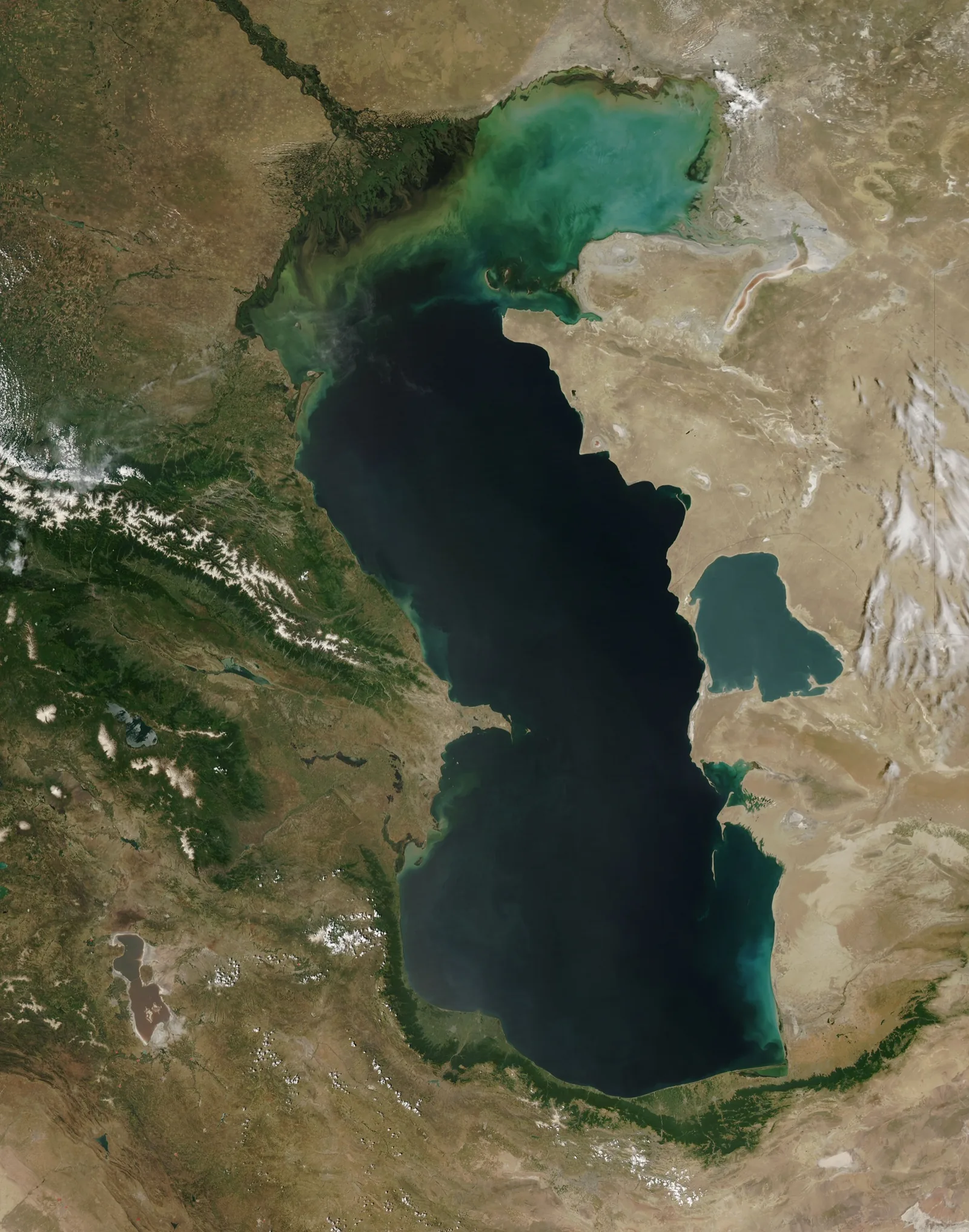
Figure 1: True-color remote sensing image of the Caspian Sea, showing the northern shallow shelf and the southern deep basin of oceanic basalt, captured by NASA satellite.
I. The Hydrological and Geological Dichotomy: Why is the Caspian Both a Lake and a Sea?
The identity of the Caspian Sea has long been shrouded in the fog of the “sea versus lake” debate, a persistent ambiguity in geographical textbooks and common knowledge. To comprehend this schism, one must disentangle the “present-day hydrological cycle” from the “paleo-evolutionary geological history of deep-seated tectonic plates,” treating them as two entirely distinct physical coordinate systems.
1. Hydrological Standards: An Undisputed Closed Inland Saline Lake
Examined through the rigorous definitions of modern hydrology and physical geography, the Caspian Sea exhibits all the physical characteristics of a typical inland lake:
- Complete Terrestrial Encirclement: The Caspian Sea’s surface is tightly surrounded by the landmasses of Kazakhstan, Turkmenistan, Iran, Azerbaijan, and Russia. It possesses no natural straits or channels connecting it to the Atlantic, Indian, or Arctic Oceans.
- Typical Endorheic Basin: The Caspian is a terminal basin, a sink where water flows in but never out. Approximately 80% of its annual inflow is contributed by the Volga River in the north, supplemented by the Ural and Kura rivers. The water body cannot naturally overflow; its sole means of egress is intense natural evaporation from its surface.
- Sub-Sea Level Elevation and Dynamic Hydrological Balance: The Caspian’s surface consistently lies about 27 to 28 meters below sea level. Its surface area fluctuates dramatically with global climate patterns, precipitation variations, and agricultural water diversions along its shores, historically ranging between 360,000 and 420,000 square kilometers.
Within modern hydrological classification, regardless of its immense physical volume—holding over 40% of the world’s total lake water and exceeding the land area of Japan—as long as it lacks a natural hydrological connection to the world’s oceans, it is hydrologically defined as a standard “terrestrial, endorheic saline lake.”
2. Paleogeology and Oceanography: A “Relict Sea” with Pure Oceanic Genes
If the Caspian were merely a lake, geologists would struggle to explain its abyssal basin floor, reaching depths of over a thousand meters, and its basaltic structure. The Caspian possesses an indelible oceanic core because its predecessor was a genuine ancient ocean.
During the Paleogene to the early Miocene epoch of the Neogene (roughly tens of millions of years ago), a vast Tethys Ocean lay between the Eurasian and Afro-Arabian continental plates. As the Eurasian and African plates collided and compressed intensely, the Tethys Ocean gradually closed and retreated, evolving into the expansive shallow sea and inland sea that stretched across present-day Central Europe, the Black Sea, the Caspian Sea, and as far as the Aral Sea—the Paratethys Sea.
The Geological Disconnection and Evolution of the Paratethys Sea:
- ~14 Million Years Ago: Intense uplift from the Alpine-Caucasus orogeny completely severed the connection between the Paratethys Sea and the Indian Ocean.
- ~5.5 Million Years Ago (Late Miocene): Further crustal uplift completely cut off the waterway that previously connected the Mediterranean Sea to the Black Sea, fragmenting the Paratethys Sea into independent basins.
- Remnant Marine Basin: The Caspian basin, originally part of an oceanic inland sea, became completely enclosed within the Eurasian hinterland, degenerating into the present-day “relict sea.”
More critical evidence lies buried at the basin’s floor: the basement of ordinary inland lakes consists of continental crust (granitic) composed of light, felsic materials, typically exceeding 30 to 40 kilometers in thickness. However, the deepest parts of the southern Caspian basin, reaching 1,025 meters, directly preserve dense, basaltic “oceanic crust” approximately only 10 to 15 kilometers thick.
On an ecosystem level, the Caspian exhibits distinct relict marine characteristics: its water salinity is about 1.2% (12‰), roughly one-third of the 35‰ salinity of the open ocean. Its waters are inhabited by the Caspian seal (Pusa caspica), which evolved from the same lineage as the Arctic ringed seal, and evolutionary branches of ancient marine fish like the Beluga sturgeon and Russian sturgeon.
Therefore, the definitive classification from the geological community is: The Caspian Sea, in terms of its tectonic geomorphology, is a fragment of an ancient ocean that has not yet fully continentalized; it is a relict marine basin persisting on land.
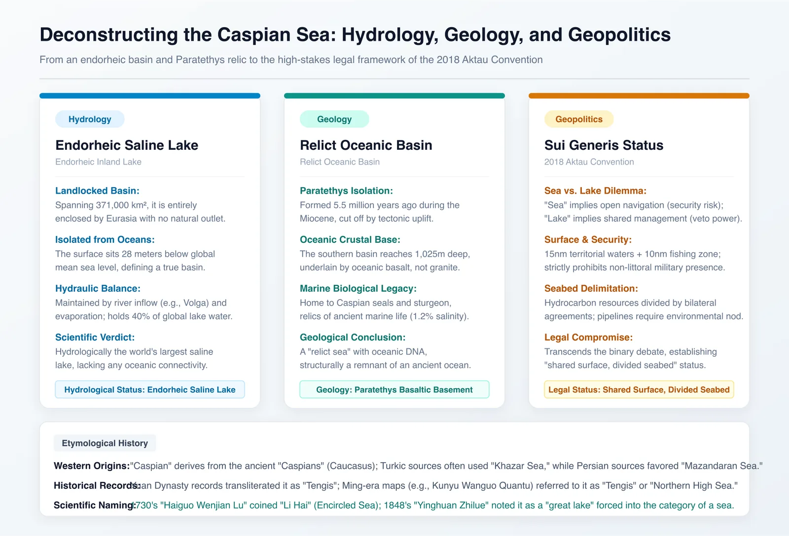
Figure 2: Deconstruction of the Caspian Sea's multidimensional attributes: endorheic hydrological basin, Paratethys oceanic crust geology, and the Aktau Convention's geopolitical matrix.
II. A Multi-Billion Dollar Definitional Gambit: The Legal Breakthrough of the 2018 Aktau Convention
If the Caspian were merely a desolate saline expanse, the debate between sea and lake would be nothing more than an academic pursuit. However, when its continental shelf was found to contain an estimated 48 billion barrels of proven oil reserves and over 8 trillion cubic meters of natural gas (a volume rivaling the Persian Gulf and Siberia), the question of “sea or lake” instantly escalated into the longest and most valuable geopolitical and legal struggle of the post-Cold War era.
1. The Legal Deadlock: “Defining as Sea” vs. “Defining as Lake”
Before the dissolution of the Soviet Union, only two sovereign states bordered the Caspian: the Soviet Union and Iran. Through treaties signed in 1921 and 1940, they maintained a balance of power for over half a century, treating the Caspian as “joint internal waters of the two countries.” After the USSR’s collapse in 1991, the number of bordering states abruptly increased to five: Kazakhstan, Turkmenistan, Azerbaijan, Russia, and Iran.
The five nations quickly realized that the legal definition of the Caspian waters would directly redraw the boundaries of hundreds of billions of dollars in wealth and geopolitical security:
| Proposed Solution | Applicable Legal Framework | Beneficiary Interests & Motivations | Potential Risks & Strategic Hedging |
|---|---|---|---|
| Option 1: Define as “Sea” | United Nations Convention on the Law of the Sea (UNCLOS) | Azerbaijan, Kazakhstan, Turkmenistan These three nations possess extensive coastlines and extremely rich offshore oil and gas fields (e.g., Kashagan, Azeri-Chirag). Under maritime law, they could claim 12 nautical miles of territorial waters and up to 200 nautical miles of Exclusive Economic Zone (EEZ), directly securing offshore hydrocarbon rights. | Strong Opposition from Russia and Iran If UNCLOS were fully applied, the central waters would become high seas, granting “freedom of navigation and overflight.” US Navy or NATO warships and research vessels could legally enter the Central Asian hinterland under the guise of transit. |
| Option 2: Define as “Lake” | Transboundary International Lake Law (Condominium) | Iran Iran has the shortest coastline, deep offshore waters, and relatively less abundant oil and gas. Under a boundary division based on coastline, it would only receive about 13% of the seabed resources. If defined as a lake with equal division among the five states, Iran could claim 20% of the water body and seabed resources. | Firm Opposition from Azerbaijan and Central Asian Nations A condominium regime for lakes requires unanimous consent from all five nations for major decisions concerning seabed pipelines and development. Russia and Iran could exercise a veto at any time, blocking the direct export of Central Asian energy to Europe. |
As we dissected the geopolitical power struggles over Caucasian pipelines in Geopolitical Power Structures: Azerbaijan and Iran, the feasibility of the Trans-Caspian Pipeline (TCP) bypassing Russia and Iran to connect to the Southern Gas Corridor fundamentally hinged on this 27-year legal battle.
2. The 2018 Aktau Convention: A “Neither Sea Nor Lake” Compromise
After nearly 30 years of marathon negotiations, the heads of state of the five littoral nations signed the landmark Convention on the Legal Status of the Caspian Sea in Aktau, Kazakhstan, in August 2018. The convention masterfully sidestepped the binary “sea or lake” dichotomy, creating a hybrid governance structure with a special legal status (sui generis):
- Surface Waters Managed as a Lake, with Strict Exclusion of External Powers:
- Littoral states delineate 15 nautical miles of territorial waters as sovereign zones, extending into a 10 nautical mile exclusive fishing zone.
- The remaining vast public water surface is for common passage and use by vessels of the five littoral states.
- Core Security Clause: The convention explicitly prohibits the military forces, warships, military bases, or military facilities of any non-littoral state from stationing, docking, or navigating within the Caspian Sea. This clause definitively ended the possibility of extra-regional superpowers intervening militarily in the Central Asian hinterland, satisfying the core security concerns of Russia and Iran.
- Seabed and Subsoil Divided According to Maritime Law Principles:
- The division of seabed and subsoil mineral resources no longer follows a “five-nation unanimous consent” condominium. Instead, neighboring and opposite states directly negotiate boundaries for exploitation through bilateral or multilateral agreements.
- Laying subsea oil and gas pipelines across the Caspian requires only bilateral agreement from the states through which the pipeline will actually pass (e.g., Turkmenistan and Azerbaijan) and compliance with international environmental assessment standards. Non-transit nations cannot exercise a political veto based on unanimous consent.
Thus, in terms of international legal status, the Caspian Sea is officially established as a composite entity: its surface is a closed, jointly managed lake strictly barring external interference, while its seabed is a clearly demarcated resource reservoir divided under modern maritime law.
III. Why is the Chinese Translation “Lihai” and Not a Transliteration?
In English and major Western language systems, this body of water is known as the Caspian Sea (Latin: Mare Caspium), and in Russian, it is Каспийское море (Kaspiyskoye more). When Chinese absorbed the Western system of modern geography, it did not phonetically transliterate it like the Caribbean Sea or the Baltic Sea. Instead, it adopted the name “Lihai” (里海). This is not a mere typographical error but the result of over two centuries of academic evolution, shifting from tribal transliteration to spatial semantic translation.
1. Etymology of the Western Name “Caspian”: An Ancient Indigenous Tribe on the Southwest Shore
The naming of this body of water by ancient Greek and Roman geographers followed the common practice of classical Western geography: the “tribal naming convention.”
- In the region southeast of the Caucasus Mountains and northwest of the Alborz Mountains (present-day southern Azerbaijan and Iran’s Gilan and Mazandaran provinces) lived an ancient indigenous South Caucasian tribe—the Caspians (Caspi).
- Ancient Greek historian Herodotus and geographer Strabo recorded this vast body of water adjacent to the Caspians’ territory as Kaspia Thalassa (Sea of the Caspians), which was later Latinized to Mare Caspium, and subsequently became the English “Caspian Sea.”
- Similarly, surrounding Turkic language groups (Turkish, Azerbaijani, Turkmen) often refer to it as Khazar / Hazar Denizi, named after the Khazar Khaganate, a nomadic empire that dominated the northern Caspian shores from the 7th to 10th centuries. Persian calls it the “Mazandaran Sea” (Daryā-ye Māzandarān), directly naming it after Iran’s northern Mazandaran province.
The naming conventions used by Western and Near Eastern civilizations essentially used a specific coastal tribe or province as a proxy.
2. The Evolution of the Caspian’s Designation in Chinese Classical Texts
Separated from the Caspian Sea by the Pamir Mountains, the Central Asian oases, and vast deserts, China’s ancient dynasties had a perception of the great western waters that evolved from vague imagination to precise scholarly investigation over centuries.
Phase 1: The General Term “Western Sea” from the Qin-Han to Tang-Song Dynasties
From Zhang Qian’s mission to the Western Regions to Gan Ying’s envoy to the Roman Empire, Chinese historical records frequently mention the “Western Sea” (Xihai). The Book of the Later Han (Hou Hanshu), in its “Account of the Western Regions,” states that Parthia “its western border reaches the great sea, which is perhaps the Western Sea.” This term sometimes referred to the Caspian Sea, and at other times to the Black Sea or the Persian Gulf. In ancient times, lacking precise cartography, “Western Sea” often served as a general designation for any vast body of water west of the Pamirs.
Phase 2: Transliteration as “Kwantianjisi” during the Mongol-Yuan Dynasty
Following Genghis Khan’s westward campaigns, the Mongol armies swept through Central Asia and Khwarazm, reaching the Kipchak Steppe. In official geographical atlases and the History of Yuan (Yuan Shi), based on the Turkic and Mongolian terms for “sea” or “great lake,” Tengis, the Caspian Sea was formally transliterated as “Kwantianjisi Sea” (Kuantianjisi Hai). This name preserved the pronunciation used by northern nomadic peoples for the great Eurasian inland sea.
Phase 3: Transitional Transliterations during the Ming Dynasty’s Western Learning Influx
In 1602, during the Wanli reign of the Ming Dynasty, Italian Jesuit missionary Matteo Ricci and Li Zhizao jointly compiled the Kunyu Wanguo Quantu (Map of Ten Thousand Countries). This map largely followed the Yuan Dynasty’s northern nomenclature, labeling the Caspian Sea as “Tengjisi Sea” (Tengjisi Hai). Later, in 1623, the Zhifang Waiji (An Account of the Five Continents) by Giulio Aleni, noting the Caspian’s proximity to the Caucasus Mountains, translated it as “Northern Gao Sea” (Bei Gao Hai). At this time, Chinese geographical circles had not yet established a unified specific name with a clear spatial conceptualization.
Figure 3: The lineage of place name evolution and hydrological classification of Eurasian inland enclosed waters by Qing Dynasty scholars.
Phase 4: The Scientific Semantic Translation Established by Qing Scholars (Chen Lunjiong and Xu Jiyu)
The creation of the specific Chinese term “Lihai” (裏海) was an academic innovation by Chinese geographers after the Qianlong and Jiaqing eras of the Qing Dynasty. They broke free from the constraints of Western tribal transliterations and established a precise semantic translation based on its spatial hydrological characteristics:
1. Chen Lunjiong’s Hai Guo Wen Jian Lu (1730): First Coining of the Term “Lihai” In the eighth year of the Yongzheng reign, Chen Lunjiong, a naval commander from Fujian, published Hai Guo Wen Jian Lu (Record of Maritime Countries), a systematic account of world sea routes. In the section “Account of the Atlantic,” Chen Lunjiong formally used the term “Lihai” (裏海) and clearly stated the reasoning behind its coinage:
“Lihai is surrounded by various countries… hence it is called Lihai.”
In the context of Chinese characters, “裏 (li)” means “inside” or “within.” Chen Lunjiong keenly captured the core characteristic of this body of water: “deeply situated within the continent, tightly encircled by Eurasian nations, and not connected to the outer oceans.” Mimicking the naming structure of the Mediterranean Sea (“sea in the middle of the land”), he created the term “Lihai,” a designation with strong geographical distinctiveness.
2. Xu Jiyu’s Ying Huan Zhi Lue (1848): Systematic Examination and Modern Definition In the 28th year of the Daoguang reign, Xu Jiyu, a towering figure in late Qing geography, published the epoch-making modern world geography encyclopedia, Ying Huan Zhi Lue (A Brief Account of the Circumnavigating World). In Volume 4, “The Various Countries of Western Asia,” Xu Jiyu not only inherited the designation “Lihai” but also provided a definitive, enduring classification with a modern, rational hydrological perspective:
“The Caspian Sea and the Aral Sea… are completely disconnected from the great sea. They are essentially large lakes, forcibly named ‘seas.’ The Westerners call it ‘Kashpi’ or ‘Gaspij.’ It receives water from the northwestern countries. Its vastness resembles a sea, but it does not connect to the great sea, hence it is named Lihai.”
Xu Jiyu’s passage accomplished three academic foundations at once:
- Alignment with Western Transliteration: He explicitly noted the Western names “Kashpi” (Kā’ěrshìbì’ān) and “Gaspij” (Jiāsībǐyuē), which were accurate transliterations of “Caspian.”
- Revelation of Hydrological Truth: He incisively pointed out that the Caspian Sea “is completely disconnected from the great sea. It is essentially a large lake, forcibly named ‘sea.’” This scientifically clarified its physical essence as a large inland lake (daze), with the term “sea” being used colloquially due to its immense size.
- Consolidation of Semantic Naming: He solidified the naming logic: “its vastness resembles a sea, but it does not connect to the great sea, hence it is named Lihai,” definitively establishing the Chinese geographical term.
With the standardization of modern Chinese characters in the 1950s, the character “裏” was simplified and merged into “里,” thus fixing “Lihai” as the standard geographical term “里海” used by Chinese speakers worldwide today.
IV. Rational Cognition: The Ultimate Unification of Geographical Attributes and Civilizational Naming
Looking back at the dual journey of the Caspian Sea through natural evolution and human civilization, we can clearly see the harmonious unification of different dimensions of perception:
- On the Spatiotemporal Scale of Earth’s Physics: It is the azure remnant left by the Tethys Ocean’s millennia of transformation within the Eurasian hinterland. Its surface is a lake, its base is oceanic, and its oceanic crust and relict marine ecosystems are indelible imprints of Earth’s tectonic collisions.
- In the Arena of Real-World Geopolitical Interests: It is a product of compromise among five nations, transcending the rigid dichotomy of “sea or lake” through the institutional innovation of the Aktau Convention, resolving the deadlock between multi-billion dollar hydrocarbon development and border security.
- In the Linguistic Evolution of Chinese Civilization: Predecessors did not mechanically adopt the tribal name “Caspian Sea” but, guided by the geographical intuition of “surrounded by nations, deeply situated within the interior,” created the term “Lihai.” Later, Xu Jiyu’s rational perspective of “essentially a large lake, forcibly named ‘sea’” completed the cognitive sublimation.
This seemingly simple “sea versus lake debate” and “etymological study” is, in essence, a vivid microcosm of the interplay between Earth’s tectonic evolution, international resource law, and the collision of modern world geography.
Related Research & Topics
Tello Mobile eSIM
SafetyWing Nomad Insurance
* Disclosure: This post contains affiliate links. If you make a purchase through these links, V-G Journal may earn a small commission at no additional cost to you. We only recommend services we independently evaluate and trust.
FIRE and Golf:自由旅居之路
专注于为追求 FIRE 与品质生活的人群提供特惠打球权益与候鸟微度假。不持一砖一瓦,运营品质生活。