The Mechanics of Tectonic Compression: Why Earthquakes Cannot Cleave a Natural Panama Canal
A geological and hydrodynamic post-mortem on the myth of a seismically carved sea-level passage across the Isthmus of Panama. From compressional microplate tectonics and elevated lock systems to mass-wasting chokepoints and lethal tidal differentials, we examine the physical fragility of modern maritime infrastructure.

Executive Thesis: A recurring speculative fiction posits that a sufficiently violent seismic event could rend the Isthmus of Panama asunder, deploying raw crustal force to carve a natural, sea-level channel connecting two oceans. Assessed against structural geology, tropical geomorphology, and open-channel fluid dynamics, the empirical probability of this scenario is zero. The lithosphere under Panama is not primed to open; it is locked in a vice. In the real world, intense tectonic motion produces only one physical outcome: triggering catastrophic, widespread slope failure that would choke, bury, and paralyze the Western Hemisphere’s primary maritime artery. Understanding these earth systems is fundamental to grasping the existential physical precarity of the global supply chain.
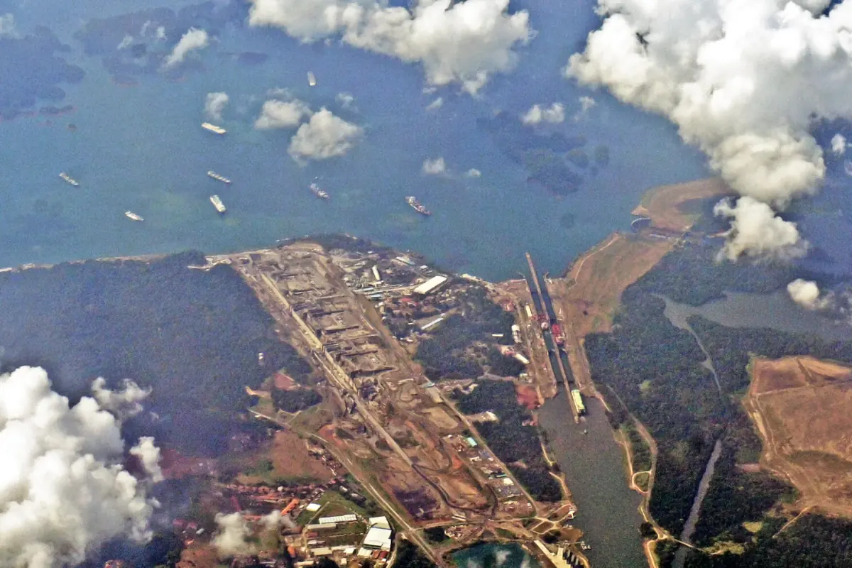
Figure 1: The Gatun Locks system: A three-tier hydraulic elevator lifting post-Panamax vessels 26 meters above sea level into an elevated inland freshwater reservoir.
I. Baseline Engineering: An Elevated Water Bridge, Not a Sea-Level Trench
Popular intuition regarding a “seismically rent canal” stems from an elementary confusion: mistaking the Panama Canal for the Suez. The Suez Canal cuts across the flat, low-lying sands of the Sinai margin—a genuine sea-level ditch where salt water flows unimpeded between the Mediterranean and the Red Sea without the intervention of a single lock.
Panama presents an entirely different physiographic reality. The isthmus is defined by the rugged topography of the Central American volcanic cordillera and the Continental Divide. From an engineering standpoint, the Panama Canal operates as a lock-and-lake freshwater bridge:
- Vertical Isolation from Sea Level: Ships crossing the isthmus do not skim across an open ocean surface. They are hoisted vertically by 26 meters via the Gatun or Agua Clara lock complexes, relying strictly on gravity-fed hydraulic equalization to reach Gatun Lake, a massive artificial reservoir in the interior highlands.
- Navigation at Altitude: Cargo vessels traverse more than 30 kilometers of mountainous interior at an elevation of 26 meters, navigating deep artificial cuts blasted through the Continental Divide, before stepping down through the Pedro Miguel and Miraflores locks to return to sea level on the Pacific flank.
- The Volume Problem: Spontaneously cleaving an open, navigable sea-level passage would require a sudden tectonic event to slice cleanly through a 50-to-80-kilometer-wide land bridge, dropping hundreds of millions of cubic meters of solid rock down to at least 15 meters below sea level. No crustal mechanism on Earth possesses the laser-focused, volumetric energy density to instantly mobilize, displace, and erase that volume of bedrock.
II. The Tectonic Paradox: Squeezed Shut, Not Pulled Apart
For nature to rift a continent and birth an oceanic strait, the underlying crust must reside within an extensional or rifting regime. Archetypal examples include the Red Sea Rift, the East African Rift System, and the Mid-Atlantic Ridge—settings where diverging tectonic plates stretch and thin the lithosphere, dropping central grabens that sea water eventually floods.
Panama operates under an inverted mechanical reality:
| Geological Metric | Extensional Rift Basins (e.g., Red Sea / East African Rift) | The Panama Microplate Stress Field (Observed Reality) |
|---|---|---|
| Crustal Stress State | Horizontal tension, crustal thinning, subsidence | Intense subduction, collision, compression, and strike-slip shear |
| Kinematic Trajectory | Divergence, opening central oceanic troughs | Crustal shortening, tectonic uplift, fault asperity lockup |
| Historical Precedent | Continental fragmentation birthing new oceans | Closure of the Central American Seaway ~3 million years ago |
| Fault Mechanics | Normal faulting, downward crustal dropped blocks | Reverse-thrust faulting, lateral strike-slip, high confining pressure |
The Panama Microplate is wedged in an active tectonic vise, pinned between the Cocos, Nazca, Caribbean, and South American plates. It is an active collision zone.
During the Pliocene epoch, roughly three million years ago, this ongoing tectonic convergence and attendant arc volcanism sealed the ancient Central American Seaway. By welding North and South America together, this collision severed low-latitude oceanic exchange between the Atlantic and Pacific, altering global thermohaline circulation—a macro-tectonic dynamic structurally parallel to the isolation of the Paratethys basin during the closure of the Tethys Ocean.
Within this compressional and strike-slip stress field, active structures like the Pedro Miguel and Limón fault zones relieve accumulated strain via vertical thrust-uplift or lateral shearing. Kilometers down, confining pressures measure in the hundreds of megapascals. Fault surfaces remain pressed tight under immense friction. The lithosphere here cannot manifest an open, vertical, cross-isthmian chasm; its stress field permits only fracturing under compression, squeezing voids shut rather than pulling them open.
III. The Mechanics of Mass Wasting: Choking the Channel
The cinematic trope of earthquakes cracking open bottomless abysses exists only in surficial, unlithified soils. Even during a rupture exceeding magnitude 7.5 or 8.0, total lateral or vertical slip across a fault trace typically measures between two and ten meters—a rounding error against an isthmus tens of kilometers wide.
The critical variable in a tropical, heavily weathered montane environment is not fracture width, but mass-wasting dynamics:
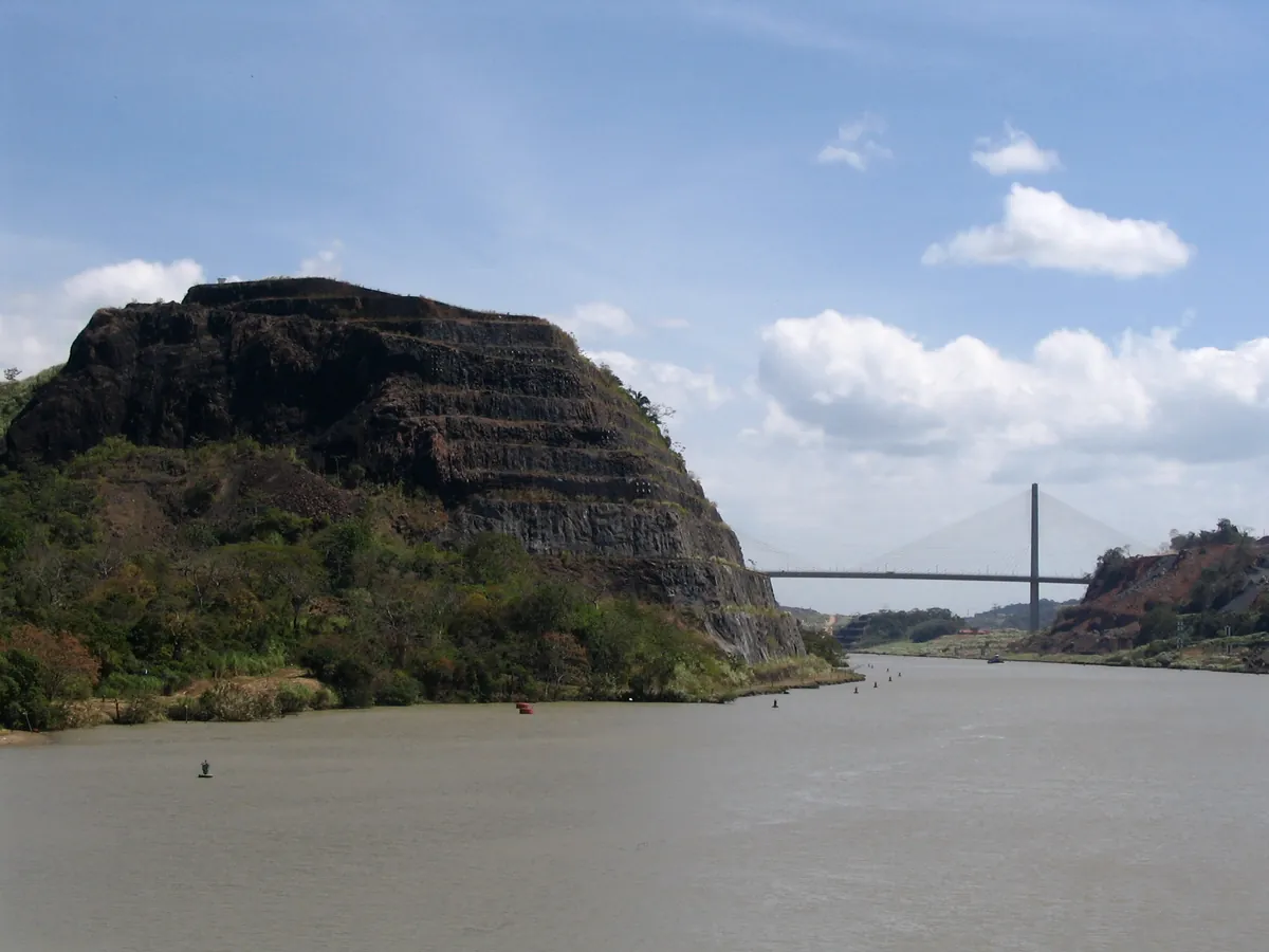
Figure 2: The Culebra (Gaillard) Cut flanking Gold Hill: The project's most precarious mechanical bottleneck, prone to deep-seated failure along soft-sediment fault planes.
- Historical Geotechnical Failures: The primary nightmare that defeated Ferdinand de Lesseps’ French enterprise and plagued subsequent American excavations was the Culebra Cut through the Continental Divide. The slopes are carved through the Cucaracha Formation, a sequence of mechanically weak clay shales rich in swelling smectite. Saturated by relentless tropical precipitation, these cuts triggered catastrophic landslides exceeding millions of cubic meters during baseline dry-and-wet cycles, burying the excavated channel repeatedly without any seismic provocation.
- Seismic Slope Destabilization: Subject these over-steepened, critically balanced cuts to violent horizontal ground acceleration, and the slopes will shear along planar and rotational failure surfaces. Tens of millions of cubic meters of weathered saprolite, basaltic fragments, and mud would plunge downslope, filling the navigation channel and nearby drainage valleys within seconds.
- Impoundment Breach and Dewatering: The canal’s operational heart is its reservoir system: Gatun Lake and Lake Alajuela (Madden Reservoir). A catastrophic rupture compromising the earthen Gatun Dam or the concrete gravity Madden Dam would release hundreds of millions of cubic meters of impounded freshwater directly to sea. Bereft of freshwater head, the lock infrastructure would instantly lose its lifting capacity. The water bridge would go dry.
A major earthquake does not cut a canal; it pulverizes, shears, and fills the existing one.
IV. The Hydrodynamic Trap: A Five-Meter Tidal Gradient
Suspend geology for a moment. Posit a supernatural rupture that cleaves a pristine, sea-level channel through the isthmus from coast to coast. Without locks to tame the water, this hypothetical trench would be functionally unnavigable.
The Atlantic and Pacific basins present a severe hydraulic head difference:
The Panama Oceanic Gradient:
- Mean Sea Level Offset: Driven by thermal expansion, prevailing trade winds, and lower ocean water density in the Pacific, the mean sea surface on Panama’s Pacific coast sits roughly 20 to 30 centimeters higher than on its Caribbean flank.
- Tidal Disparity: The Caribbean Sea operates as a microtidal basin, displaying an astronomical tidal range of just 0.5 to 1.0 meter. The Gulf of Panama on the Pacific side experiences an energetic semi-diurnal regime with macro-tides swinging 5.0 to 6.0 meters.
Directly connecting these two bodies through an open, sea-level trench would create a dynamic, multi-meter hydraulic head that shifts continuously over the lunar cycle.
Open-channel hydraulics dictates that this gradient would unleash roaring currents through the narrow channel, reaching velocities of 10 to 15 knots or higher. These would manifest as violent tidal bores, reversing direction every six hours. In constricted, winding cuts, this volume would produce violent shear zones, hydraulic jumps, standing waves, and dynamic scour banks.
A modern, laden container vessel or dry-bulk carrier displacing 100,000 to 150,000 deadweight tons requires electric shore locomotives (“mules”) and high-bollard-pull tugs just to maintain heading in the still waters of a lock chamber. Introduce a 12-knot cross-current and turbulent hydraulic eddies into a narrow rock cut, and hydrodynamic rudder stall is immediate. The vessel’s extreme momentum would swing it broadside, driving its hull into the basalt walls of the canyon.
V. The Legacy of Nuclear Excavation and Real Supply Chain Risk
Civil engineers have historically modeled whether brute kinetic force could bypass these topographical limits.
During the peak of the Cold War in the 1960s, Lawrence Livermore National Laboratory evaluated this premise under Project Plowshare. Their objective: carve a sea-level canal through Central America—evaluating routes across the Sasardí-Mortí region of Panama or the Atrato basin in Colombia—using civilian nuclear detonations. The blueprint proposed detonating salvos of thermonuclear devices totaling tens of megatons buried in series along the route, vaporizing and ejecting hundreds of millions of cubic yards of rock to yield an unobstructed, 300-meter-wide sea-level passage.
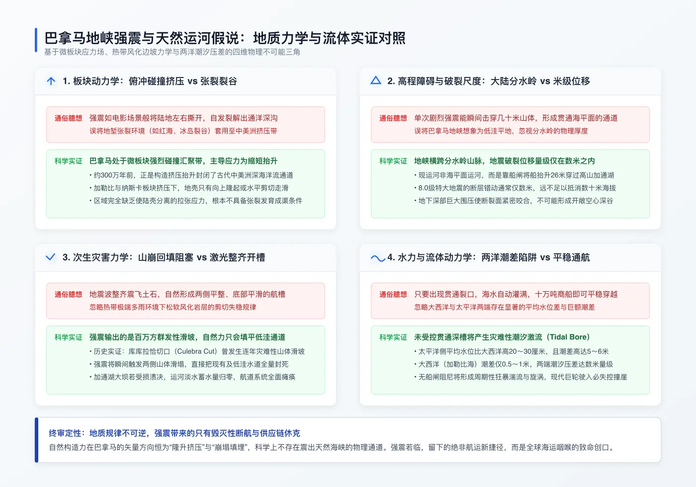
Figure 3: Analytical cross-validation: Evaluating stress regimes, topographic elevations, slope mechanics, and tidal hydraulics against the natural canal fallacy.
The program was ultimately abandoned. Beyond the obvious hazards of radioactive fallout and the diplomatic fallout of test-ban treaties, the geotechnical verdict was fatal: the complete instability of post-blast slopes.
Blasting a deep cut does not produce a stable channel; it shatters the surrounding country rock. Under tropical rainfall, shattered slopes inevitably slump until they reach a drastically lower angle of repose. The nuclear cut would have backfilled itself with debris within weeks of excavation. If engineered, sequentially detonated thermonuclear charges cannot maintain a stable, open-trench cross-section through these formations, chaotic seismic waves will not do so either.
When natural processes realign global trade corridors, they do not do so by tearing trenches across compressional collision zones. The real structural shifts occur through gradual planetary phase changes—most visibly today in the progressive loss of multi-year Arctic sea ice, which is slowly turning the Northeast and Northwest passages into viable seasonal realities.
Should a severe, low-frequency rupture strike the deep faults of the Panama Isthmus, nature will offer no new shortcut. Instead, it will present an infrastructure crisis: shattered lock walls, breached retaining dams, millions of tons of colluvium burying the channel, and a fractured global supply chain forced to route hundreds of vessels around Cape Horn and through the Strait of Magellan.
Related Research & Topics
Tello Mobile eSIM
SafetyWing Nomad Insurance
* Disclosure: This post contains affiliate links. If you make a purchase through these links, V-G Journal may earn a small commission at no additional cost to you. We only recommend services we independently evaluate and trust.
FIRE and Golf:自由旅居之路
专注于为追求 FIRE 与品质生活的人群提供特惠打球权益与候鸟微度假。不持一砖一瓦,运营品质生活。